![](/images/other/stat-length.png)
![Tocht Stappen Les Haies - Croix Régis - circuit du Croizat - 9,7 km - 272 m de dénivelé - 3h - Photo](https://media.geolcdn.com/t/1900/400/ext.pjpeg?maxdim=2&url=https%3A%2F%2Fstatic1.geolcdn.com%2Fsiteimages%2Fupload%2Ffiles%2F1553511878bg_sport_marche.png)
Croix Régis - circuit du Croizat - 9,7 km - 272 m de dénivelé - 3h
Clubléorando
Gebruiker
![Lengte](/images/other/stat-length.png)
![Max. hoogte](https://static1.geolcdn.com/siteimages/upload/files/1508320355ic_sort_altitude_max_24dp.png)
![Positief hoogteverschil](https://static1.geolcdn.com/siteimages/upload/files/1508320355ic_sort_den_pos_24dp.png)
![Km-Effort](/images/other/stat-length.png)
![Min. hoogte](https://static1.geolcdn.com/siteimages/upload/files/1508320355ic_sort_altitude_min_24dp.png)
![Negatief hoogteverschil](https://static1.geolcdn.com/siteimages/upload/files/1508320355ic_sort_den_neg_24dp.png)
![Boucle](https://static1.geolcdn.com/siteimages/upload/files/16400158638029165_repeat_loop_refresh_sync_direction_icon.png)
![Stappen](https://static1.geolcdn.com/sitytour/trail-icons/101.png)
3h00
Moeilijkheid : Gemakkelijk
![Scan deze QR-code om de tocht te openen in de SityTrail-applicatie](https://capi.geolives.com/qq0zvz2zws4bq2lad0pu/sitytour/trails/3226891/qr.png?size=200)
Gratisgps-wandelapplicatie
Over ons
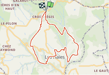
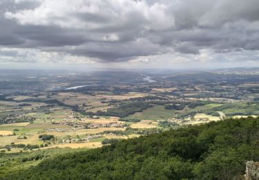
Tocht Stappen van 9,7 km beschikbaar op Auvergne-Rhône-Alpes, Rhône, Les Haies. Deze tocht wordt voorgesteld door Clubléorando.
Beschrijving
Ballade en boucle au départ du parking de Croix Régis. Prendre la direction sud jusqu'à la côte 338 puis remonter en direction nord et traverser le village des Haies. Prendre la direction est et contourner le hameau du Croizat. Amorcer le retour en passant par le hameau la Sainty puis remonter en direction nord jusqu'à la côte 503, lieu du départ
Plaatsbepaling
Opmerkingen
Wandeltochten in de omgeving
![Tocht Stappen Loire-sur-Rhône - 42 le grisard (vienne) - Photo](https://media.geolcdn.com/t/375/260/c8c552c2-c833-47f9-98c4-fadea207952f.jpg&format=jpg&maxdim=2)
![Stappen Stappen](https://static1.geolcdn.com/sitytour/trail-icons/101.png)
Stappen
![](/images/other/stat-length.png)
![](https://static1.geolcdn.com/siteimages/upload/files/16400158638029165_repeat_loop_refresh_sync_direction_icon.png)
![Tocht Stappen Saint-Romain-en-Gal - le grisard - Photo](https://media.geolcdn.com/t/375/260/ext.jpg?maxdim=2&url=https%3A%2F%2Fstatic1.geolcdn.com%2Fsiteimages%2Fupload%2Ffiles%2F1553511878bg_sport_marche.png)
![Stappen Stappen](https://static1.geolcdn.com/sitytour/trail-icons/101.png)
Stappen
![](/images/other/stat-length.png)
![](https://static1.geolcdn.com/siteimages/upload/files/16400158638029165_repeat_loop_refresh_sync_direction_icon.png)
![Tocht Stappen Échalas - 69-echalas-17km-450m - Photo](https://media.geolcdn.com/t/375/260/668703a5-09d9-4217-ad43-166e3f818dc1.jpg&format=jpg&maxdim=2)
![Stappen Stappen](https://static1.geolcdn.com/sitytour/trail-icons/101.png)
Stappen
![](/images/other/stat-length.png)
![](https://static1.geolcdn.com/siteimages/upload/files/16400158638029165_repeat_loop_refresh_sync_direction_icon.png)
![Tocht Stappen Loire-sur-Rhône - 69-loire-sur-rhone2-pet-de-loup-18km-560m - Photo](https://media.geolcdn.com/t/375/260/ee6f14b8-8ed9-4a30-84a4-6a7d5babc72f.jpg&format=jpg&maxdim=2)
![Stappen Stappen](https://static1.geolcdn.com/sitytour/trail-icons/101.png)
Stappen
![](/images/other/stat-length.png)
![](https://static1.geolcdn.com/siteimages/upload/files/16400158638029165_repeat_loop_refresh_sync_direction_icon.png)
![Tocht Stappen Longes - 1 septembre 2022 longes - Photo](https://media.geolcdn.com/t/375/260/b8e593b2-5bab-42a8-9612-49feaf9d31d5.jpg&format=jpg&maxdim=2)
![Stappen Stappen](https://static1.geolcdn.com/sitytour/trail-icons/101.png)
Stappen
![](/images/other/stat-length.png)
![](https://static1.geolcdn.com/siteimages/upload/files/16400158638029165_repeat_loop_refresh_sync_direction_icon.png)
![Tocht Stappen Longes - 69-longes-Mont-Monnet-Ste-Croix-Jarez-20km-800m - Photo](https://media.geolcdn.com/t/375/260/ac0cbb02-60a0-4176-82bd-78c0bd941465.jpg&format=jpg&maxdim=2)
![Stappen Stappen](https://static1.geolcdn.com/sitytour/trail-icons/101.png)
Stappen
![](/images/other/stat-length.png)
![](https://static1.geolcdn.com/siteimages/upload/files/16400158638029165_repeat_loop_refresh_sync_direction_icon.png)
![Tocht Stappen Loire-sur-Rhône - 69-Loire-sur-Rhone-17km-480m-avr22 - Photo](https://media.geolcdn.com/t/375/260/13a86102-41dd-4011-b432-58d1cdb1bc2f.jpg&format=jpg&maxdim=2)
![Stappen Stappen](https://static1.geolcdn.com/sitytour/trail-icons/101.png)
Stappen
![](/images/other/stat-length.png)
![](https://static1.geolcdn.com/siteimages/upload/files/16400158638029165_repeat_loop_refresh_sync_direction_icon.png)
![Tocht Te voet La Chapelle-Villars - Pilat N°30: des «Côteaux à les Haies» - Photo](https://media.geolcdn.com/t/375/260/dcae721c-56d2-4080-8395-c9b2db29b909.jpeg&format=jpg&maxdim=2)
![Te voet Te voet](https://static1.geolcdn.com/sitytour/trail-icons/100.png)
Te voet
![](/images/other/stat-length.png)
![](https://static1.geolcdn.com/siteimages/upload/files/16400158638029165_repeat_loop_refresh_sync_direction_icon.png)
![Tocht Stappen Ampuis - AMPUIS JC - Photo](https://media.geolcdn.com/t/375/260/ext.jpg?maxdim=2&url=https%3A%2F%2Fstatic1.geolcdn.com%2Fsiteimages%2Fupload%2Ffiles%2F1553511878bg_sport_marche.png)
![Stappen Stappen](https://static1.geolcdn.com/sitytour/trail-icons/101.png)
Stappen
![](/images/other/stat-length.png)
![](https://static1.geolcdn.com/siteimages/upload/files/16400158638029165_repeat_loop_refresh_sync_direction_icon.png)